Hickory UWCD No. 1
Tools & Technologies
Hydromodelhost
In 2017, Hickory UWCD No. 1 (HUWCD) began using a cloud-based modeling software, Hydromodelhost. The platform allows the district to integrate real-time data from the field with aquifer availability models and run different scenarios to see predicted outcomes. The district uses this model when new permit applications come in to run scenarios and determine what impacts a new well(s) might have on nearby wells, as well as the effect on the aquifers and streamflow in the district. Previously, HUWCD relied on draw down models to show the impact to neighboring wells when assessing new permits.
In addition to being a decision support tool, the new platform also allows them to input scenarios and forecast what will happen 20, 30 or even 50 years in the future. HUWCD has been using the software for just a few months, but says they have already seen gains in operational efficiency as this new tool has come online.
Recharge Rates
The district has recently acquired an additional 20 rain gauges. These are deployed throughout the district along with water level monitors. These gauges are also connected to their online platform and their data is uploaded in real-time. Besides adding an additional data point to their new 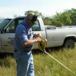 management platform, the district intends to use the rain gauges to calculate aquifer recharge rates. HUWCD hopes to have a clear picture of recharge rates in the outcrop portion of the Hickory Aquifer within the year, while the rates in the downdip will take longer to obtain. Once recharge rates are established, they will become another data set used to determine the Desired Future Conditions (DFCs).
Education & Outreach
Educational Sponsorships
HUWCD’s board is committed to using district resources for outreach and education efforts. The board recently pledged $5,000 to the Mason Pioneers Youth Leadership Group as they work to construct a rainwater harvesting system that will be used to water the high school practice field. In addition to this sponsorship, the board is also a Legacy Sponsor of the Texas 4-H Water Ambassadors Program, which provides high school students an opportunity to gain advanced knowledge and practice leadership skills related to the science, technology, engineering, and management of water in Texas. Beyond sponsorships, the district makes annual presentations at local high schools and to civic groups.
Challenges
Local Aquifer Conditions
 One of the more complex technical challenges faced by the district is to understand the faulting within the district’s aquifers. These faults affect the movement of groundwater, the depth of wells, and groundwater production, which in turn effects how permits are issued. The district completed a study on the San Saba Aquifer that shows vertical and horizontal faulting, leading to shifts of a ½ to ¾ of a mile in some areas. Knowing where faults occur can save some landowners upwards of 450 feet of depth when drilling a new well. HUWCD worked with a graduate student to preform the San Saba study and hopes to do the same for the Hickory Aquifer.
Helpful Resources
Visit the Hickory Underground Water Conservation District No. 1 website at hickoryuwcd.org.