Presidio County Underground Water Conservation District
Published June 29, 2021 by Julia Stanford
Presidio County UWCD is based in Marfa, the seat of Presidio County. The county shares more border with Mexico than it does with its adjacent Texas counties, with 135 miles of the mighty Rio Grande making up the county’s southern and western edges. About half of the water used for irrigation in the county is surface water diverted from the Rio Grande, but all other water users rely on groundwater. Population growth in the region and surrounding cities, a heavy agricultural and ranching heritage, and increased oil and gas activity in the Permian Basin have created a unique set of water users and water management challenges in the county.
Water Demands
Although it is remote, Far West Texas is not exempt from the rampant population growth in Texas. Several municipalities in the district have drilled or are drilling new wells to accommodate a rise in population and tourism, and domestic demands on the groundwater supply will only increase. Population growth in the region’s neighboring cities, such as Midland, Odessa, and El Paso will continue to drive “water ranching” activities in the region. The term “water ranching” is used by some to describe municipalities purchasing large swaths of land in order to secure the rights to the groundwater below the surface. For example, the city of El Paso already owns land near the Presidio County line that could eventually be used as a water supply for the growing city.
The region is also experiencing an unprecedented expansion of unconventional oil and gas exploration in the greater Permian Basin. A recent study by Duke University found that water use in the Permian Basin has risen by 770% since 2011. New innovations in horizontal drilling and other techniques could place even heavier demands on water in years to come. With landowners in neighboring Culberson County already exporting 5.4 million gallons of water a day to the oilfields, the leadership of Presidio County UWCD is preparing for the potential future impacts that these increased water demands may have on shared groundwater resources.
Presidio County UWCD must walk a fine line between conserving the resources and protecting the rights of landowners to produce groundwater, and management decisions will need to be more data-driven as foreseeable conflicts become reality. Presidio County UWCD is currently spared the immediate impacts of these water demands, but is in a perfect position to gather the data necessary to help gauge the effects of regional population growth and unprecedented oil and gas activity. As the adage goes, you can’t manage what you don’t measure.
Data Management
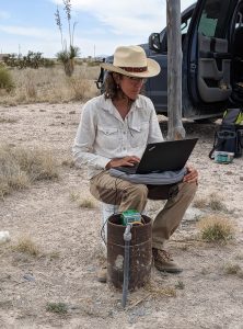
General Manager Carolyn Macartney downloads water level data from a monitoring well near Marfa (photo credit Blake Neffendorf)
Presidio County UWCD aims to accurately account for all groundwater use in order to deepen the understanding of the geology and water use in the Igneous and Rio Grande Aquifer systems. The district has designated four new monitor wells within the last two years, with plans to add two more in the coming year. The monitor wells record data daily. The district purchased a data management system from Halff Associates last year. This is a database system that allows the district to organize, analyze, and store data for the groundwater resources that it manages, including information from the monitor wells, Texas Water Development Board (TWDB) recorder wells, and other wells in Presidio County.
While this software can help Presidio County UWCD manage groundwater locally, the district seeks to expand the influence of its data by joining the US Geological Survey’s National Ground Water Monitoring Network (NGWMN). The USGS recently awarded the district with a grant to maintain the data and share it with the NGWMN. There is a large gap in the network in Far West Texas, and adding the Presidio County UWCD wells will ensure that the region’s groundwater trends are considered by the professionals at the USGS. “Becoming a data provider to the National Ground Water Monitoring Network not only furthers the mission of the USGS at the national level, it also unlocks tremendous funding opportunities for water quality testing and drilling our own monitor wells, which would otherwise be out of our price range at the local level here in Presidio County,” said Trey Gerfers, board chairman of Presidio County UWCD.
Collaboration in GMA 4
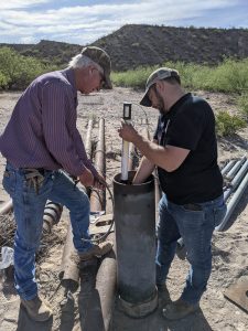
Board member David Williams and field tech Blake Neffendorf installing ecolog 1000 monitor equipment in a well in S. Presidio County. (photo credit Carolyn Macartney)
Presidio County UWCD is also working with the Big Bend Conservation Alliance and other groundwater conservation districts in its groundwater management area (GMA 4) to establish a common data management software platform in the region and provide for better coordination of regional water management goals. The proposed collaboration would usher in a new era of data management for Brewster County GCD and Culberson County GCD, by enabling the districts to gather and centralize data from ongoing monitoring programs, expand those programs, and integrate existing historical data from spreadsheets and other storage locations. A streamlined database for each district would facilitate point-in-time decisions and provide the ability to easily search all of the data in the district’s possession. This platform would save districts significant time by having information on hand to respond to public information requests and provide for integrated access to data from the TWDB, other state agencies, and county appraisal districts. Currently, all data must be accessed separately and cross-referenced manually.
By joining forces across county lines and acquiring a common data management platform, it gives the region a shared view of each district’s data on the aquifers they share and provides for better coordination of regional water management goals. Presidio County UWCD is actively working toward making decisions with a regional perspective based on hard data.
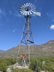
Board Chairman Trey Gerfers looking for wells to monitor in the Chinati State Natural Area (photo credit Carolyn Macartney)
Trey Gerfers will present more information about the data management challenges faced by his district and others in GMA 4, as well as their proposed solutions, at the upcoming Texas Groundwater Summit in San Antonio. His presentation will be part of the “Addressing Challenges in Groundwater Management” breakout track on September 1. Click here to register and see more information about the Texas Groundwater Summit.
Visit pcuwcd.org to learn more about Presidio County UWCD.