Monthly Feature
TexMesonet Offers Network of Reliable Weather Data
Published by Julia Stanford on 12/2/2020
The weather affects us in a multitude of ways, particularly when it comes to the important work of groundwater management. Of course, integrating weather into groundwater management requires good data. Thankfully, water users, managers, and the general public can use TexMesonet to get reliable weather data from across the state in one place.
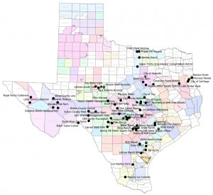
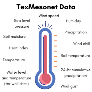 TexMesonet is a statewide earth observation data collection network. A partnership effort led by the Texas Water Development Board (TWDB), this network of over 1,400 weather stations spans the entire state. Weather stations collect dozens of data points at varying intervals, which are automatically transmitted via telemetry and made available for public use on texmesonet.org.
Data are valuable to GCDs and water users
TexMesonet was created in 2016 in response to the Memorial Day floods of 2015 to help mitigate impacts of floods and other extreme weather events. By delivering accurate, on-the-ground weather information from deliberately placed stations, TexMesonet makes weather patterns and effects more easily discernible on a local and regional basis. TexMesonet allows data be viewed in three ways – data on current conditions, weather forecasts from the National Weather Service, and graphs showing trends from the last 24 hours-2 weeks. Users can also download additional maps and data products from TexMesonet that show seasonal precipitation and temperature patterns across the state.
In a recent TAGD survey about TWDB water data resources, every GCD that used the TexMesonet website reported that precipitation information was most useful to the district. GCDs reported that they can use precipitation and drought data in determining their drought stage triggers, issuing drought status notifications, recommending pumping curtailment, and estimating pumpage and recharge. Districts indicate that they utilize real-time data, forecasts, historic data, or a combination of those in making groundwater decisions.
The atmospheric data provided on TexMesonet.org is especially useful for agricultural water users, who can utilize temperature, precipitation, wind information, and soil moisture data to inform their irrigation decisions. TexMesonet data can be automatically fed into commercially available irrigation software and used to inform water management decisions. With about 80% of groundwater use statewide attributed to agricultural irrigation, anything that helps farmers irrigate more efficiently will ultimately lead to substantial groundwater savings.
While other water users may not be as obviously vulnerable to meteorological changes as agricultural users, information regarding precipitation (whether historical data or forecasted) can be a key piece in all water-related decisions. GCDs that connect their water users to this high-quality weather data may see improved groundwater efficiency and conservation.
GCDs throughout the state partner with TexMesonet
Many GCDs have contributed to the TWDB’s effort to build out the TexMesonet network of weather stations. These partnerships can take several forms and can include providing funding to install a new station, assisting with siting a station, maintaining a station, or sharing data. Because some stations must be located on private property, GCDs can be especially helpful in the siting of potential stations with landowners with whom they already have positive working relationships. Fifteen GCDs so far have worked with TWDB and district landowners to find suitable sites for TexMesonet stations. The Edwards Aquifer Authority and Guadalupe County GCD are two examples of districts that have taken their TWDB partnership to the next level.
Guadalupe County GCD was an early supporter of the TexMesonet and remains a valuable collaborator for the project. In 2016 the district provided funding for seven TexMesonet stations within the county, and recently staff has taken on the task of maintaining the stations on a regular basis. One notable weather station is located right next to a Guadalupe County GCD monitor well. The selection of this site is particularly valuable, as it filled a gap in coverage by the TWDB while also providing Guadalupe County GCD with site-specific data on how weather patterns may affect aquifer conditions as measured at the monitoring well. This mutually beneficial partnership improves the collection and sharing of high-quality weather data with the public and provides the data needed to guide groundwater management decisions. Guadalupe County GCD General Manager Kelley Vickers, looks forward to learning from the data collected by the weather stations: “At some point, it’s going to be really interesting to see how long it takes rainfall to get into the aquifer. We have had rain events and then seen a rise in the water level at the monitoring well, but we’re not sure if the recharge is from that rain event or one six months ago in another area. When we start looking at that we’ll have plenty of data to determine those patterns.”
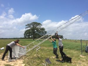
Guadalupe County GCD General Manager Kelley Vickers, TWDB Director Kathleen Jackson, and TWDB staff Leyon Greene install a weather station in Guadalupe County in 2018.
The Edwards Aquifer Authority (EAA) has also been a TexMesonet partner 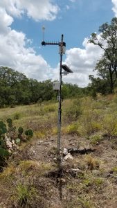 since shortly after its creation. Back in 2014, EAA had created its own network of weather stations and rain gauges. When the TexMesonet website launched in 2016, EAA began sharing the data from 8 of those weather stations for display on the TexMesonet website, and now contributes data from over 60 stations. EAA uses climatic and soil moisture data from these weather stations to calculate evapotranspiration, or ET. ET causes water loss after precipitation events, so having the atmospheric data specific to their region allows EAA to more accurately estimate groundwater recharge. This in turn allows for more effective management of groundwater. EAA’s Director of Data Management, Bryan Anderson, said “Weather data is very helpful as water modelers attempt to drill down on inputs to the aquifer. Our karst systems are very susceptible to rainfall, so this wide network of precipitation data, along with ET, helps us fill in the data gaps of the hydrologic cycle.”
Getting involved with TexMesonet
Getting involved in TexMesonet can be a win-win situation for the TWDB and GCDs! TexMesonet stations are spaced out very intentionally, and there is a need for stations in certain areas that are not yet covered. Typically, a partnership with a GCD consists of a TWDB-owned station that is maintained regularly by someone at the GCD. TWDB can easily train a staff member with a broad technical background to assist with this regular maintenance
TexMesonet provides an opportunity for GCDs to make the data from nearby stations available on their website in real time, thereby providing a valuable service to water users while improving their own data collection and decision-making. And if a district maintains its own weather stations, they can use telemetry to push the data to TexMesonet to make it easily accessible to anyone using the TexMesonet website, without the GCD incurring costs related to maintaining a weather station widget, database, or map on their own website. EAA’s Bryan Anderson described the decision to connect their weather stations to TexMesonet as a “no-brainer.”
What’s next for TexMesonet? Program Manager Nathan Leber plans to coordinate an advisory committee in early 2021 to gather input from current and potential end users so that network growth, data collection, and product creation continue to serve water users, managers, and planners across all sectors in Texas. Leber says “the advisory committee would benefit from the strength of the relationships that GCDs have with landowners, agricultural producers, and municipalities across Texas.” And of course, TWDB will continue to seek partnerships with GCDs both for existing stations and to develop new ones that can help fill the data gaps.
TexMesonet is a valuable resource that can be beneficial to GCDs and groundwater users. Through its partnerships, TexMesonet is able to provide reliable weather data that is critical for groundwater management decisions. If you’re interested in providing data from a station or maintaining a TWDB station, please contact the TexMesonet Program Manager Nathan Leber at Nathan.Leber@twdb.texas.gov.