High Plains UWCD
Permitting
When issuing drilling permits, the High Plains Underground Water Conservation District (HPWD) Board considers whether the proposed well conforms to the spacing and production rules.
Quick look at permitting rules in HPWD
- Production rate: Non-exempt wells shall follow an Allowable Production Rate (APR) of 1.50 acre-feet per contiguous acre per year (18 inches).
- Spacing requirements: Wells producing more than 17.5 gpm must be drilled a minimum distance from the nearest well site and from the nearest property line. The spacing distance varies according to production of the new well.
- Online applications: HPWD is in the process of implementing an online permit request platform.
- Link to rules: click here
Permit Stats for 2018
- Drilling Permits: 522 permits issued
- Dockum Aquifer: 26 permits
- Edwards-Trinity (High Plains) Aquifer: 1
- Ogallala Aquifer: 495 permits
- Exempt well registrations: 2
District Programs
Irrigation Assessment Program
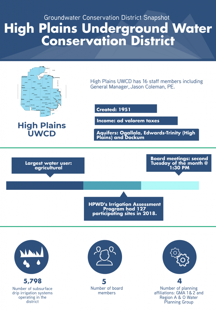
HPWD reinstated its Irrigation Assessment Program in 2013. Cooperating producers volunteer to have their center pivot or subsurface drip irrigation system evaluated by HPWD staff. Water levels in wells are measured at the beginning and end of the growing season. In addition, flow rates of the wells/irrigation systems are checked with an ultrasonic flow meter. This service is provided by HPWD at no cost to willing participants.
The pumping hours, total gallons of water per minute, and the number of irrigated acres are calculated to determine the total acre-inches of groundwater applied during the growing season. Rainfall totals are determined through the use of radar estimates from April to September. This gives an estimate of the total inches of water available for plant use.
Water samples are also collected as an extra service to those participating in the program. HPWD is able to check Total Dissolved Solids (TDS), chloride, and pH levels of groundwater.
All of the data compiled throughout the course of the program is not just a benefit to the producers, but provides the HPWD with a more information on aquifer conditions.
For example, the 2018 program participants’ well data reveals an average depth-to-water of 225 feet and an average flow rate of 108 gallons per minute. The average amount of irrigation water applied in 2018 by program participants was 15.2 inches for corn,15 inches for silage, 11.3 inches for cotton, and 5.7 inches for wheat.
Additional Programs
Assistance in Irrigation Management Program (AIM)
Since 2017, HPWD has received a total of $375,000 from the Texas Water Development Board as cost share funding for the AIM Program. AIM is a voluntary program that helps producers with the purchase price of telemetry-based irrigation monitoring systems used with either a center pivot system or subsurface drip irrigation system. The program proved to be a popular one—the first round of funding was claimed in less than two weeks and the second round in three days.
Outreach
Since 2014, HPWD has sponsored a series of workshops to share rainwater harvesting information with the public. Approximately 93 persons attended the three workshops in 2018. Staff distributed 75 rainwater harvesting barrels at last year’s workshops. HPWD also publishes a monthly newsletter, The Cross Section, which celebrates its 65th year of publication in June 2019. It is available either by email or in print.
Helpful Resources
Visit HPWD’s website at hpwd.org.