Northern Trinity GCD
Published November 15, 2023 by Julia Stanford
 Does Fort Worth ever cross your mind? Whether you’ve been boot scootin’ in the Stockyards or sitting in the stands for any of the iconic Texas Rangers brawls, most Texans have had some sort of memorable experience in Tarrant County. You may have even taken the 255 ft. plunge on the epic Titan rollercoaster at Six Flags Over Texas… and if you keep going down below the surface of all that Tarrant County has to offer, you’ll find precious groundwater resources that span the region.
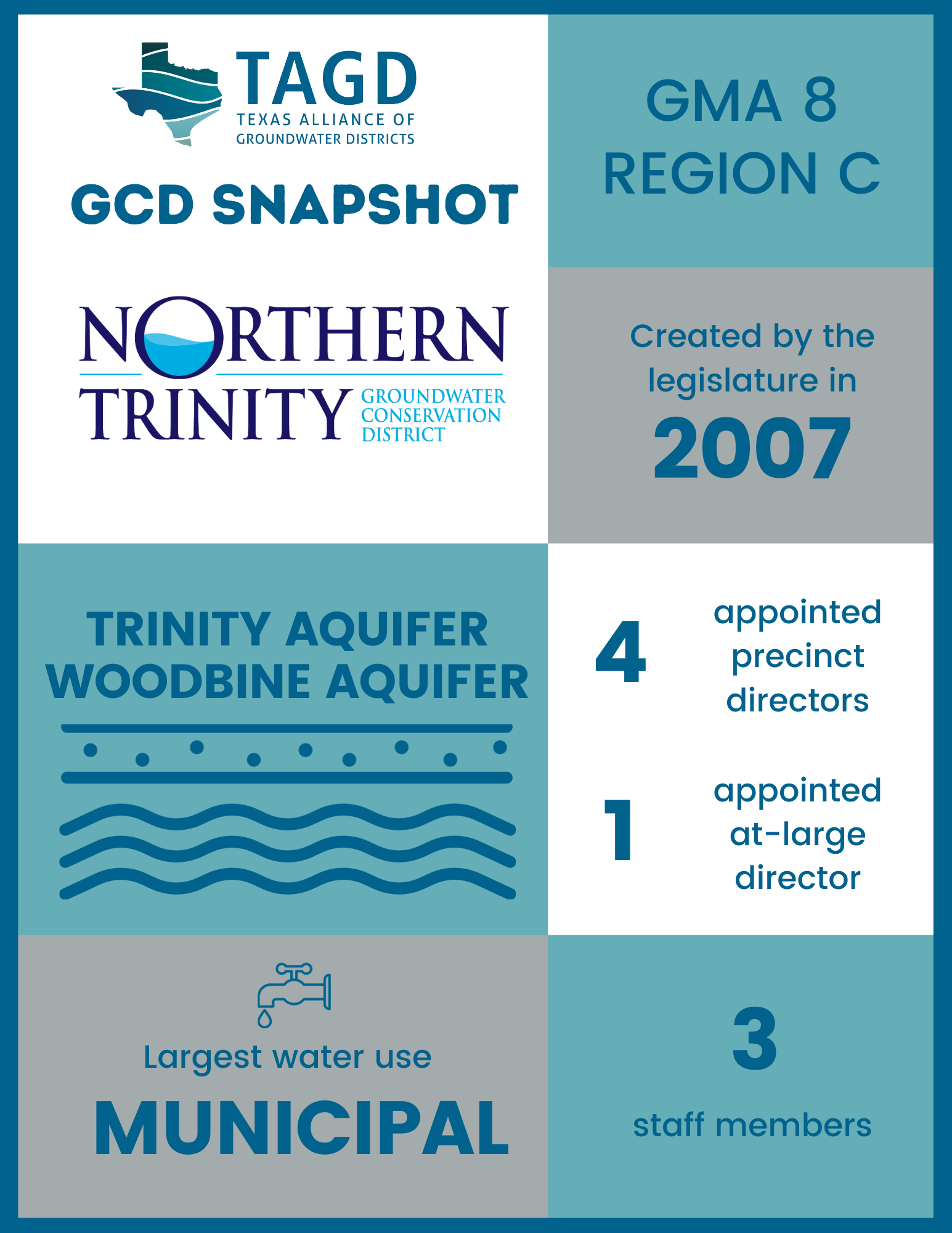
Northern Trinity Groundwater Conservation District manages groundwater production in both confined and unconfined portions of the Trinity aquifer and Woodbine aquifer within the boundaries of Tarrant County. Although Northern Trinity GCD is a single-county district, it has a population of over 2 million people. Most residents in the county receive their water supply from large utilities like the City of Fort Worth and City of Arlington, which purchase raw surface water and do not rely on groundwater. The district’s largest groundwater producers are smaller cities such as Euless, Kennedale, and Benbrook, which use a combination of purchased surface water and produce their own groundwater supplies. While the metroplex has significant surface water reservoirs that currently make up 90% of the region’s water supply (according to the 2021 Region C Water Plan), it is still important to protect groundwater resources at the apex of the “Texas triangle.”
 PGMA Beginnings
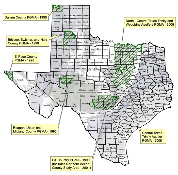
Northern Trinity GCD was created in 2007 as a result of the Priority Groundwater Management Area (PGMA) study process. The Texas Commission on Environmental Quality (TCEQ) can designate a portion of the state as a PGMA if it is experiencing, or expected to experience, critical groundwater shortages or other problems in the next 25 years. After studying the supply and demand of the Trinity and Woodbine aquifers in the growing Dallas-Fort Worth metropolitan area (DFW) in 2005-2006, TCEQ found that groundwater withdrawal was far exceeding groundwater recharge. The study area report cited an anticipated population increase of 4 million people, an estimated 1.1 million additional acre-feet of water demand, and increased oil and gas development of the Barnett Shale as factors creating “overdraft conditions” for the two aquifers.
In late 2006, TCEQ issued a draft report that recommended PGMA designation for a large portion of the DFW region. This included a recommendation for the establishment of a multi-county GCD covering thirteen DFW-area counties. However, the Texas Legislature instead opted to pass enabling legislation for the creation of a handful of smaller districts. In 2007, the 80th Texas Legislature passed House Bill 4028 to create a single-county groundwater conservation district in Tarrant County – Northern Trinity GCD. Neighbors to the west subsequently confirmed the creation of Upper Trinity GCD as authorized by the legislature during that same session. North Texas GCD, Red River GCD, and Prairielands GCD were all created two years later in the 81st legislative session in response to the PGMA order.
Technology & Science
Science and technology are a priority for the Northern Trinity GCD as they work to manage the groundwater resources of Tarrant County. The district’s board knew that investing in science was important, even in the early days after its creation. This was demonstrated when – before even hiring staff – the board voted to partner with several other GCDs in Groundwater Management Area 8 (GMA 8) to fund improvements to the groundwater availability model that is still used for joint planning.
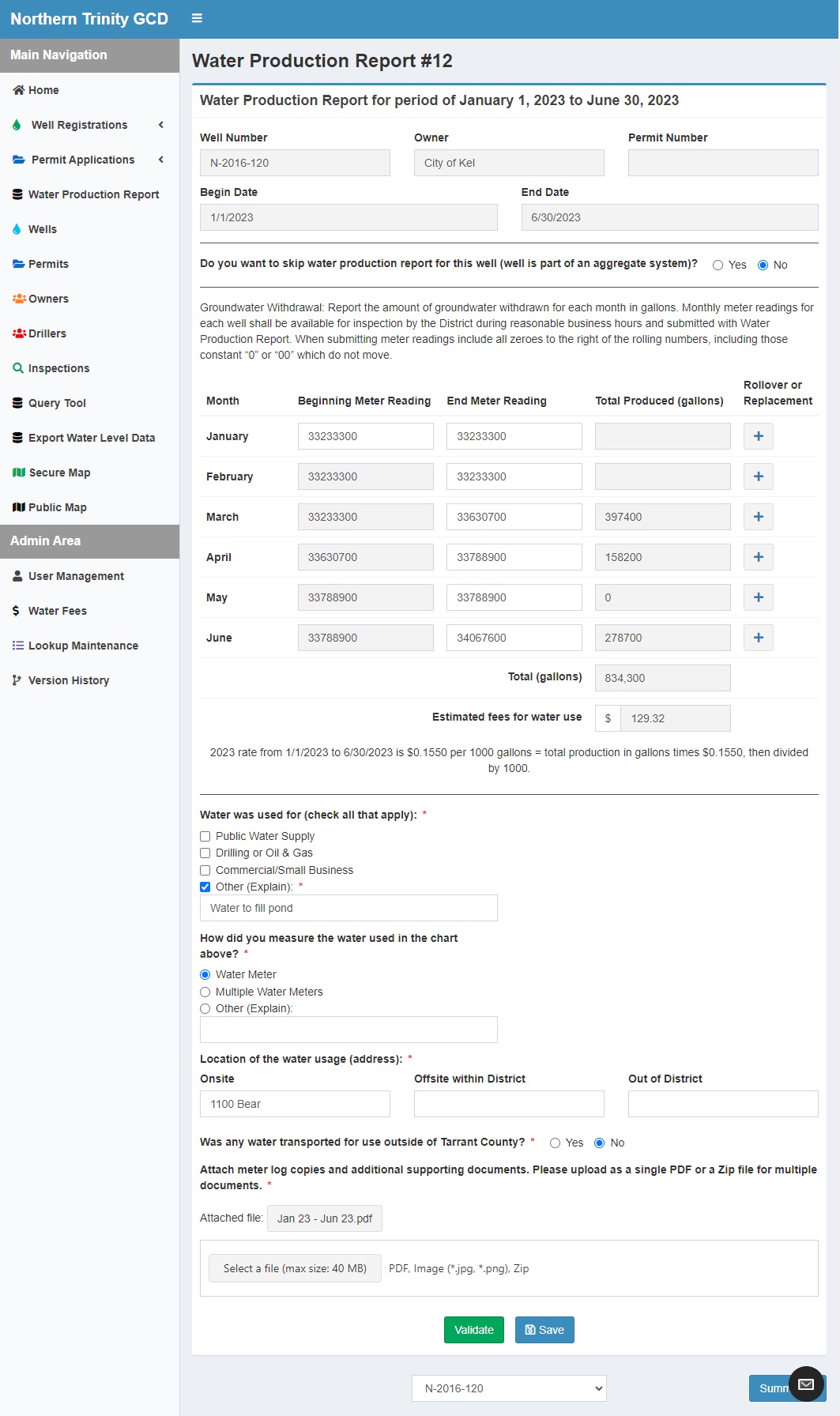
This commitment to science and technology has continued. The Northern Trinity GCD has invested in technological tools such as the Water Production Reporting portal and the district’s online interactive map. The Water Production Reporting tool allows non-exempt users to register for an account and submit groundwater pumping figures for all of their wells electronically in one place. This tool then calculates production fees based on the reported figures. This streamlined process eases the administrative burden of groundwater management for permittees and staff alike.
Northern Trinity GCD recently introduced an online map that allows the public to have access to a suite of tools and well information. The map displays registered wells, well reports from the Texas Water Development Board (TWDB), plugging reports, water utility service areas, major and minor aquifer boundaries, and flood plains. This interactive map viewer also incorporates a tool that allows users to select a location on the map and receive a “virtual bore” report to learn approximate figures for depth to formation and formation thickness. This feature can be helpful for landowners that are curious what groundwater resources lie beneath their property, and for well drillers researching ideal well locations.


Monitor Wells
Northern Trinity GCD’s biggest management challenge is building their network of monitor wells. As former TWDB director Kathleen Jackson frequently evangelized, “The better the data, the better the science; and the better the science, the better the policy.” The district recognizes that data from strategically placed monitor wells is imperative in painting an accurate picture of the health of their aquifers. District staff have worked with many private landowners and cities to gain access to wells that offer reliable water level data, and they are seeking new partnerships to bolster their current network of 30+ wells.
Additionally, Northern Trinity GCD has begun purchasing and installing continuous water level monitoring equipment on several monitor wells throughout the county. The district has also worked with TWDB to identify and configure a continuous water level monitoring site using TWDB equipment. These real-time water level readings, in addition to the quarterly measurements from wells without telemetry, provide the district with more data points to help form a comprehensive view of water level trends. This data also strengthens scientific models and allows for more informed policy decisions at the district and GMA level.
To learn more about Northern Trinity GCD and to check out their online interactive map, visit the district’s website at www.ntgcd.com.