Harris-Galveston Subsidence District
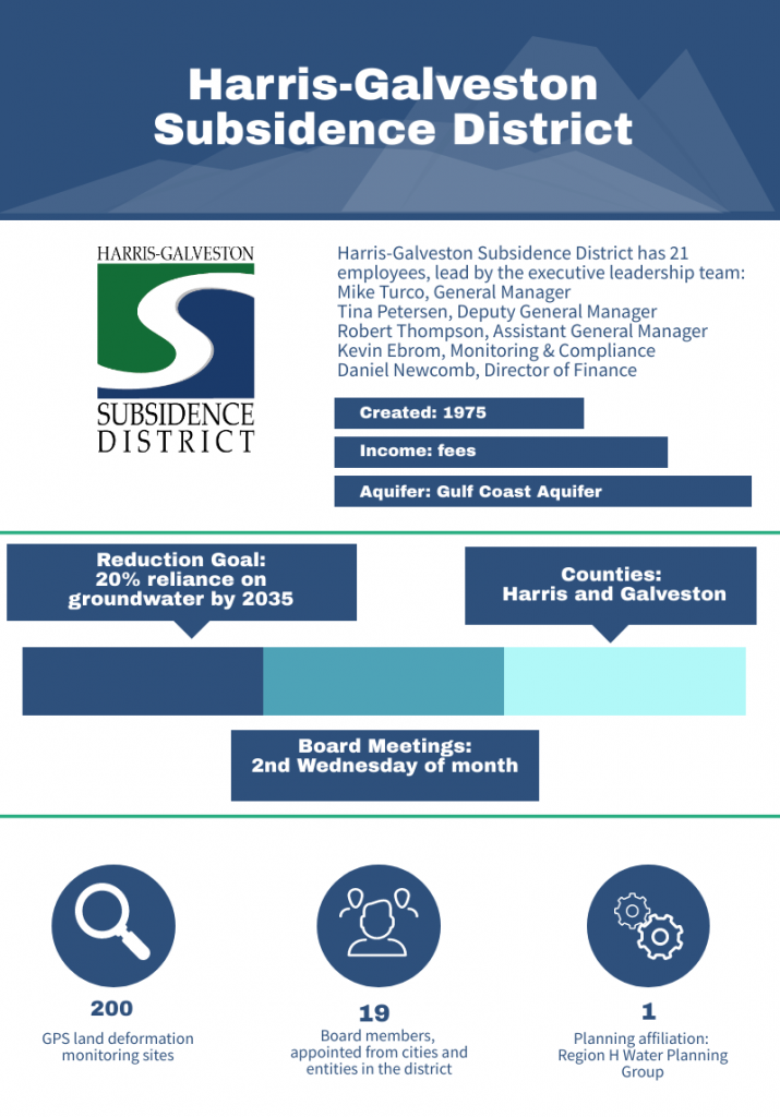
 The Harris-Galveston Subsidence District is a special purpose district created by the Texas Legislature in 1975 to regulate groundwater withdrawal throughout Harris and Galveston counties in order to prevent land subsidence. While some of the duties and goals are similar to those of groundwater conservation districts, Harris-Galveston Subsidence District (HGSD) is not governed by Chapter 36 of the Texas Water Code. In addition to regulation, the district also conducts research to enhance its understanding of the Upper Gulf Coast aquifer to better manage subsidence.
Regulatory Plan Review
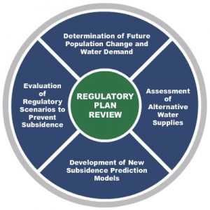
Harris-Galveston Subsidence District’s main mechanism of regulation is through its regulatory plan, with requirements laid out in the district’s enabling legislation. Now on its fifth iteration since 1976, the plan describes the different regulatory areas throughout the district, defines groundwater withdrawal limits for each area, and provides guidelines for permitting.
Occasionally, the district undertakes a review of the regulatory plan, working with other entities to assess future water needs and ensure that the plan will be successful in ceasing subsidence. With the last regulatory plan adopted in 2013, HGSD recently initiated a joint regulatory plan review in cooperation with the Fort Bend Subsidence District (FBSD) in January 2020. The review of the plan includes the following steps:
- Develop population and demand projections for 10 counties through 2100
- Conduct alternative water supply assessment
- Develop the Gulf Coast Land Subsidence and Groundwater Flow (GULF)-2023 model with US Geological Survey and Texas Water Development Board
- Update the analytical subsidence models previously used by the HGSD and FBSD
- Evaluate regulatory scenarios
The initial stakeholder meeting for the joint regulatory plan review will take place May 20, 2020 and future progress meetings will be scheduled periodically throughout the project. Water supply evaluation and population projections are underway. Additionally, the US Geological Survey (USGS) has begun work on the GULF-2023 model, with an anticipated completion date in the fall of 2021. This model will provide valuable information to inform the regulatory decision-making of the HGSD and FBSD.
GULF-2023 Model Development & USGS Partnership
The GULF-2023 model is a new $588,000 endeavor jointly funded by the HGSD and FBSD, in cooperation with USGS. The model will simulate the impacts of groundwater use on aquifer water levels and land subsidence throughout the region and will be used to evaluate regulatory scenarios of interest to both subsidence districts.
A focus of these scenarios will be on the variables that minimize subsidence in the future while accounting for the availability of alternative water supplies. The variables to be explored include:
- Alternative water supply availability
- Regulatory methodology
- Climate change and drought
- Groundwater regulation (or lack thereof) in adjacent counties
 “Since the District was created in 1975, our focus has been on preventing subsidence through reasonable regulation of groundwater use,” says Mike Turco, General Manager of HGSD, “our commitment to cutting-edge research and consistent investment in the highest-quality data collection, with agencies like the USGS, has provided a firm scientific basis for a successful regulatory plan.” The new GULF-2023 model will be the latest product in a large body of scientific activities initiated by HGSD. You can view research studies, model information, and interactive maps under the Science & Research tab of the HGSD website.
The USGS has a long history of working with HGSD and other entities in the Houston region. In fact, the USGS serves as the hub for an annual multi-agency data collection effort that includes the Brazoria County GCD, Lone Star GCD, the City of Houston, and both subsidence districts. This effort has published aquifer levels and subsidence data since 1975 and is a great example of what can be accomplished through sustained collaboration between, city, county, regional, and federal partners. Click here to view information and publications from USGS about groundwater and subsidence on the Texas Gulf Coast.
HGSD lies within the boundaries of Groundwater Management Area 14 (GMA 14). Since it is not a GCD, HGSD participates in the activities of GMA 14 as an inter-local participant. Since the creation of the GMA, HGSD has provided information, research, and financial support to the GMA process. Harris-Galveston Subsidence District, Fort Bend Subsidence District, and the USGS are working closely with the Texas Water Development Board to ensure that the GULF-2023 model will be available as a regional tool for GMA 14 to provide the best science and planning information for the region.