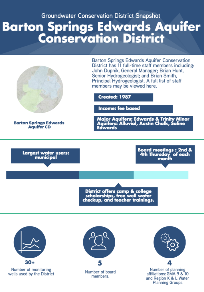
Barton Springs Edwards Aquifer CD
Aquifer Science and Research
The Barton Springs Edwards Aquifer Conservation District (BSEACD) Board values and supports science that informs their policy decisions. Because of this, the District is involved in various internally and externally funded groundwater research and assessment programs. To protect and manage the groundwater resources of the District’s aquifers, BSEACD conducts an active research program that is designed to better understand the hydrogeology and hydrodynamics of aquifers in the district, and to advise the Board of Directors on policy-related decisions.
Some of these studies include numerical groundwater modeling, dye tracing, recharge enhancement, drought status, water-quality sampling, and a water-level measurement program involving more than 30 monitor wells. Recent studies have focused on the feasibility of desalination of the saline Edwards Aquifer and aquifer storage and recovery (ASR) in the saline Edwards and the Trinity Aquifers. View some of the district’ scientific papers here.
Data Management
 In their efforts to make science based permitting and policy decisions and manage a large voWaterLevelMeasurement.JPGlume of data, BSEACD is going through a data management overhaul. Because BSEACD is actively working with, reporting and evaluating various types of data, the District has recognized that an integrated data management and reporting system works best for their needs.
BSEACD’s new data management system will be designed to collectively support the District’s various workflow needs and will include the following functionalities: web based interactive mapping tools; permitting workflow processes such as online well registration and online production reporting; interfacing applications that allow for multiple users permissions; comprehensive well data associated with ownership, location construction, water levels, water quality, metered groundwater production, well classification, and production permits; hydrologic data management including additional dynamic links to TWDB databases; drought compliance management; data management and reporting related to Desired Future Conditions (DFCs), Modeled Available Groundwater (MAG), and the Habitat Conservation Plan (HCP).
Permitting Approach
BSEACD evaluates all individual permit requests through a three-part test. The first part of the test is to ensure the requested pumpage volume be reasonable and non-speculative, and that the volume estimates are in line with the proposed use type. The District also looks for assurance that there are plans and intent to use the water for beneficial purposes within the near term.
The second part of the test is applied to permit applications for large-scale production. These permits are evaluated to assess the potential for localized impacts attributed to the proposed pumping projects. These assessments are based on aquifer tests, a hydrogeological report required to support the application, and application of the best available science to predict drawdowns and the potential for unreasonable impacts to existing wells. Finally, each application is evaluated to assess the potential impacts to the applicable Desired Future Conditions (DFCs), which is a long-term evaluation of the cumulative impacts of the aggregate pumping on a regional scale. Those types of evaluations require more complex tools, modeling, and ongoing aquifer monitoring and data collection to assess actual and predicted impacts to the DFC. The MAG is also a factor considered in this evaluation.
GCD Programs and Services
BSEACD implements a variety of programs, services, and events through out the year. They range from water quality testing to scholarship
 programs. Below are a few of the recent and upcoming programs and services that the District offers.
Well Water Checkup (Apr. 19): Well owners in the District can bring in water samples for free analysis for bacteria, nitrates, and salinity (TDS). This program started as collaboration with the Texas Well Owner Network through their grant opportunity, and the District has continued it through the years.
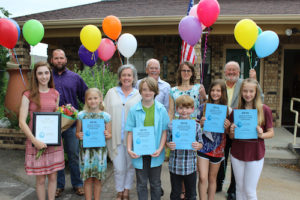
Aquatic Science Adventure Camp Scholarships (due Mar. 22): The District, in collaboration with our permittees, sponsors scholarships for students ages 9-15 through the Aquatic Science Adventure Camp at Texas State University in San Marcos. Winners attend camp run by Texas State University Edwards Aquifer Research and Data Center.
Kent Butler Memorial Groundwater Stewardship College Scholarship Essay Contest The District’s college scholarship is dedicated as a memorial scholarship honoring one of Austin’s most influential environmental planners, Kent Butler. The $2,500 scholarship can be applied toward tuition for any college, community college, or training institution.
Groundwater to the Gulf: A Summer Institute for Educators (Jun. 13-15): Every year, water experts from over 13 agencies in Central Texas combine forces to take 50 teachers to the aquatic hotspots. This institute equips teachers with activities and knowledge to help bring local science issues into the classroom.
Barton Springs Hackathon: This was a one-day, hands-on, technical workshop focused on unlocking hydrologic data in central Texas for public consumption. With support from the Hill Country Alliance, the District teamed up with the Texas Advanced Computing Center to host the first Barton Springs Hackathon!
Opportunities & Challenges
The primary challenges of BSEACD are maintaining springflow and critical habitat for endangered species during extreme droughts, water supply planning in one of the fastest growing regions in the state, and attempting to balance private property rights with the needs of historic users and their investment-backed expectations from an aquifer with limited or fully prescribed availability.
These same challenges have also lead to the some of the District’s biggest opportunities including: advancing science through feasibility studies of innovative water supply strategies such as aquifer storage and recovery (ASR) and brackish groundwater desalination, continued characterization of the District’s aquifers to provide the science that informs sound policy, and developing partnerships with local stakeholders to collaboratively plan and solve water supply problems.
Helpful Resources
Visit bseacd.org to learn more about the District and their programs, services, research projects, outreach efforts, and more.