GCD Index
For help exploring the database, click the User Guide button at the top. For any technical issues or questions, please email info@texasgroundwater.org.
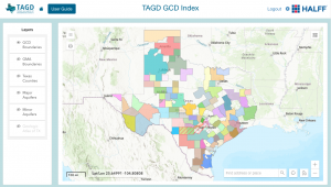
The new and improved GCD Index is a fully interactive representation of the TAGD GCD database. It includes detailed information about the state’s groundwater conservation districts in an easy map viewer. You may select layers including aquifers and GMA boundaries, click around to identify GCDs in a given area, and even export data from the searchable table below the map. We hope you find this tool easy to use and a valuable addition to our website.
Developed in partnership with:
This map viewer and associated information on this website is being made available by TAGD as a public service. The information provided has been self-reported by GCDs to TAGD. TAGD requests updated information from GCDs at regular intervals, with the current data collected in 2023. While TAGD strives to ensure that information made available to the public through this website is accurate, it has not been independently verified and some errors may exist. TAGD assumes no legal responsibility for the accuracy or completeness of the information contained on this website.


