Drought Index
Check out the Texas Water Development Board’s drought-related website, www.waterdatafortexas.org, which provides the most comprehensive information available on the current and historical status of Texas reservoirs.
What is a drought?
The National Drought Mitigation Center (NDMC) at the University of Nebraska-Lincoln provides a helpful overview on drought and defines the term as “originat[ing] from a deficiency of precipitation over an extended period of time, resulting in a water shortage for some activity, group, or environmental sector.” It is not a term to be used in a vacuum, but instead considers regional attributes and social factors.
Drought is actually relatively common, but the extent of the drought conditions can vary dramatically. As summarized by the TWDB, drought typically has three phases:
- meteorologic drought (a period of lower than normal precipitation);
- soil moisture/vegetative drought (impacts plants, wildlife and crops); and
- hydrologic drought, resulting in lower stream flow, lake levels and well levels.
In the 1950s, Texas experienced what many refer to as “the drought of record”. The state responded to the drought and its devastating effects by creating the TWDB in 1957. As described below, the current Texas drought has not yet surpassed the drought of the 1950s, but with the National Weather Service predicting the drought to continue or intensify in most areas, it is possible that this drought could become the worst one the state has seen since it started keeping records in 1895.
Drought Preparedness Council
In 1999, the Texas Legislature created the Drought Preparedness Council, an interagency committee with the purpose of:
- assessing and reporting drought monitoring and water supply conditions;
- advising the governor on significant drought conditions;
- recommending provisions for inclusion in the state emergency management plan and the state water plan;
- advising the regional water planning groups on drought-related issues in the regional water plans;
- ensuring effective coordination among state, local, and federal agencies in drought-response planning; and
- reporting to the legislature, not later than January 15 of each odd-numbered year, regarding significant drought conditions in the state.
The Texas Division of Emergency Management, a subdivision of the Texas Department of Public Safety, chairs the Council. TAGD Member David Van Dresar (Fayette County GCD) sits on the Council on behalf of TAGD. Other members include TWDB, TCEQ, Texas Parks and Wildlife Department, Texas Department of Agriculture, Texas AgriLife Extension Service, State Soil and Water Conservation Board, Texas Department of Housing and Community Affairs, Texas Forest Service, Texas Department of Transportation, and Texas Department of Economic Development.
The functions, responsibilities, and duties of the Council are codified in Texas Water Code sections 16.055 and 16.0551.
Current Texas Drought Conditions
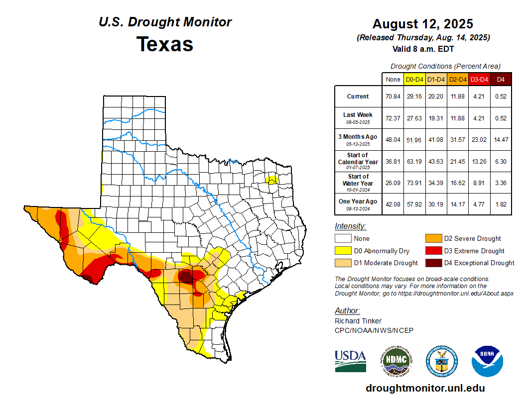
According to the U.S. Drought Monitor, current drought conditions are as follows:

For more information, visit the specific drought indices and maps, found at the following locations:
- Crop Moisture Index
- Palmer Drought Severity Index
- Standardized Precipitation Index
- Keetch-Byram Drought Index
- Reservoir Storage (by climatic region or river basin)
- Streamflow Index
- Percent of Normal Precipitation (scroll to middle of page)
Other Helpful Resources:
- U.S. Drought Monitor
- Texas Water Development Board Drought Page (comprehensive overview including map creation tools)
- Texas Commission on Environmental Quality Drought Page
- TCEQ’s map of public water systems under water use restriction
- Office of the Texas State Climatologist (includes map creation tools)
- Current Burn Bans
- Texas Lake Levels
- National Integrated Drought Information System
- TWDB Daily Well Water Levels
- Article – Drought’s Impact on Energy Supply
